Back to: Environmental Biology 400 Level
Welcome to class!
Let’s imagine a road is about to be constructed through a rural community in Kogi State. What effects will this project have on the environment—on wildlife, people, farmlands, and water bodies? Before answers can be given, experts must figure out exactly what impacts may arise and how serious they’ll be. This is where methods for identifying and predicting environmental impacts come in. It is one of the most critical parts of the Environmental Impact Assessment (EIA) process.
Methods For Impact Identification & Prediction
Understanding Impact Identification and Prediction

Impact identification is about discovering all the possible ways a proposed project might affect the environment—positively or negatively. Prediction takes it a step further by estimating how big or serious those impacts will be, how long they might last, and what areas they might affect.
These two steps allow planners, developers, and communities to make informed decisions and reduce future environmental problems before they occur.
Key Methods for Impact Identification
Checklists
These are simple tools that list possible environmental factors—like air quality, noise, vegetation, and soil. As each factor is considered, experts tick whether the project will have a negative, positive, or neutral effect. Checklists are widely used because they’re quick and easy to apply.
Matrices
Think of a matrix as a table. One side lists project activities (e.g. land clearing, drilling, construction), and the other side lists environmental factors (e.g. air, water, soil, health). Each cell of the matrix is filled with the expected type and severity of impact. This method helps in comparing multiple effects side by side.
Networks
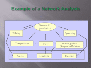
This method uses diagrams to show cause-and-effect relationships. For example, cutting down trees leads to erosion, which leads to water pollution. Networks help identify indirect and long-term impacts.

Overlays and GIS (Geographic Information Systems)
Here, different maps are layered to understand spatial impacts. For instance, one map may show farmland, another may show wetlands, and another may show the proposed project. Overlaying them reveals where impacts may overlap. GIS makes this even more accurate and detailed.
Expert Judgment and Delphi Method
In situations where data is limited, expert opinions are relied upon. The Delphi method involves gathering anonymous expert views, summarising them, and feeding the summary back to the group until a consensus is reached.
Environmental Risk Assessment (ERA)
ERA uses scientific data and probability to predict the chance of environmental harm. For example, what is the risk of an oil pipeline bursting, and how bad would the damage be? This method is especially useful for industrial or hazardous projects.
Why These Methods Matter
Imagine if the Lekki Deep Sea Port was built without understanding its impact on the nearby mangroves, fishers, and local communities. Using the right methods not only protects the environment but also helps avoid costly mistakes, legal problems, and community resistance.
Nigerian Example: The Zungeru Hydroelectric Project

Before construction began in Niger State, different impact identification tools were used to assess risks to biodiversity, water flow, and community displacement. Based on predictions, compensation plans were made, and water management strategies were included in the design.
Summary
- Impact identification finds potential environmental effects of a project, while prediction estimates how serious those effects could be.
- Common methods include checklists, matrices, networks, overlays with GIS, expert judgment, and risk assessments.
- Each method helps identify direct, indirect, long-term, and short-term impacts.
- Accurate predictions help planners propose effective solutions and avoid future problems.
- Case studies like the Zungeru Dam show how these tools are used in Nigerian projects.
Evaluation
- What is the difference between impact identification and prediction?
- Name and briefly explain three methods used for identifying environmental impacts.
- What kind of projects might benefit most from GIS overlay methods?
- Why is expert judgment used in some cases?
- Give one Nigerian project where impact prediction was essential and explain why.
You’re doing incredibly well! Remember, the better we get at predicting environmental impacts, the better we can protect Nigeria’s land, water, people, and future. Keep learning, keep leading—Afrilearn is cheering for you every step of the way!
